The number of cisterns documented in excavations at the site.[10]
DIGITAL DOCUMENTATION OF CULTURAL HERITAGE
çel(bîr)a
A digital memory record of a production landscape carved into stone.
A TÜBİTAK 2209-A research project making the Çelbira Ancient Wells visible through architecture, archaeology and augmented reality.
105rock-cut cisterns
10grape-processing areas
AR + 3Bdigital documentation
Scroll down ↓
01 / SITE
A PRODUCTION MEMORY IN THE MARDIN PLAIN
Topography, stone
and flow.
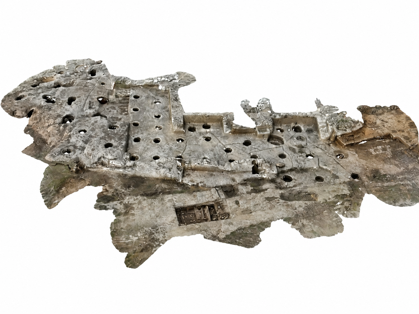
One of the lesser-known examples of ancient production landscapes, the Çelbira Ancient Wells form a multilayered cultural landscape near the main campus of Mardin Artuklu University, with cisterns carved into the bedrock and traces of production.
The traces across the site require the slope, channels, collection areas and production units to be read as an integrated system. Çelbira is considered one of the earliest known examples of ancient grape-processing installations.
37°19′ N40°44′ EArtuklu / Mardin
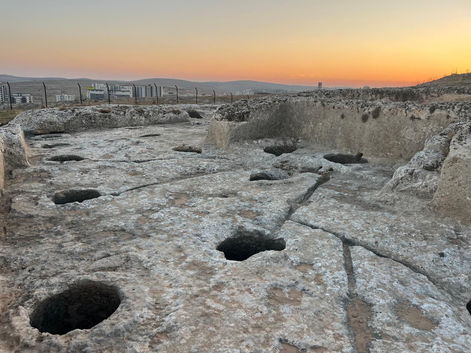
General view of the production landscape
Openings and channels carved into the rock surface reveal how the site relates to its topography.
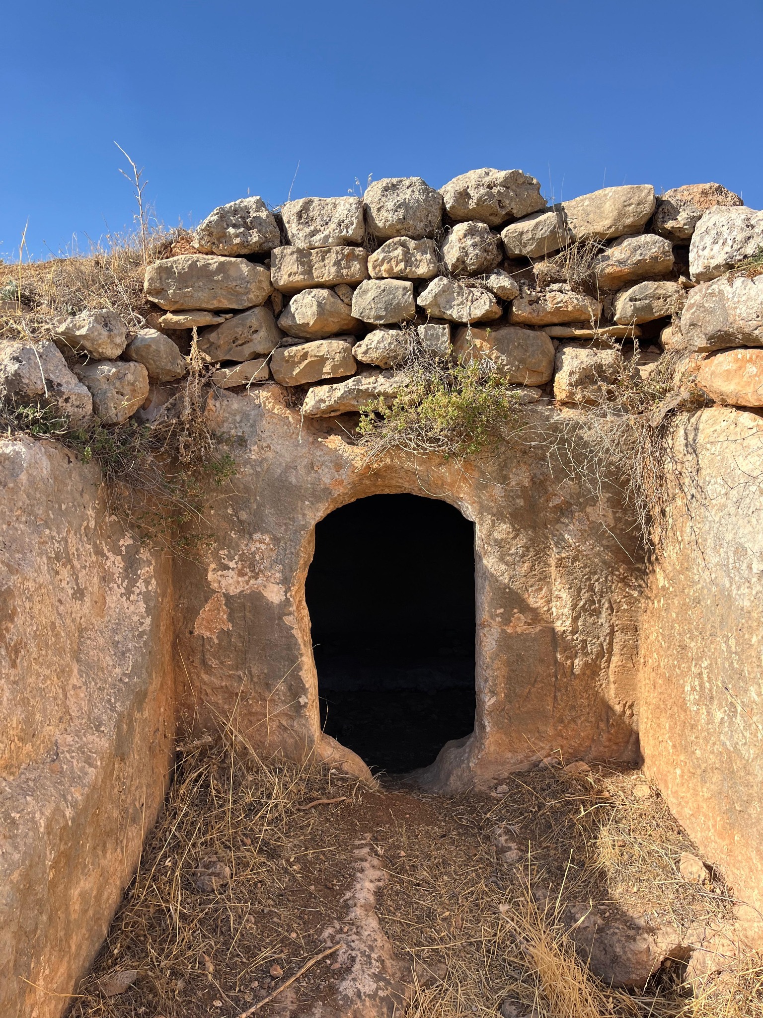
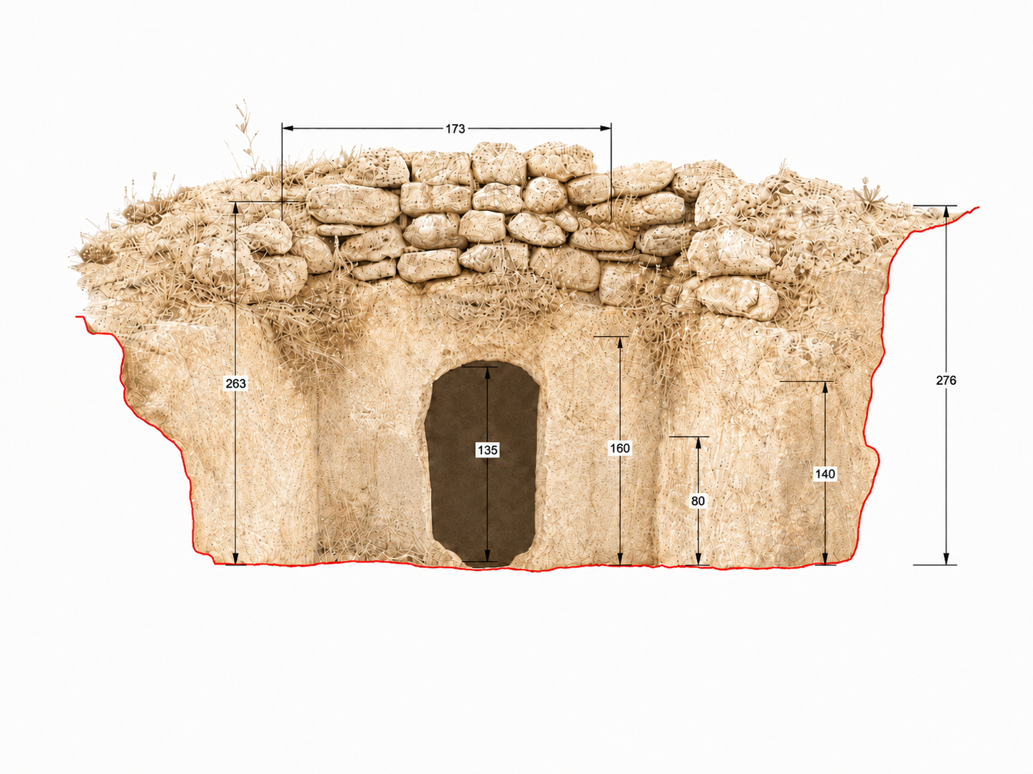
Rock-cut tomb
One of the rock-cut tombs on the slopes of Çelbira; the natural rock mass and dry-stone walling above can be read together.
DIGITAL ARCHIVE / 3D
INTERACTIVE SITE MODEL
Explore Çelbira in three dimensions.
Rotate the site model to examine it from different angles, zoom in on details and switch to full-screen view. On mobile devices, use two fingers to zoom.
Preparing the 3D model%0
Drag to rotate · Scroll or pinch to zoom
02 / RESEARCH
FIELD NOTES FROM A PUBLISHED STUDY
Reading Çelbira through data.
Kutlu and Şimşek’s 2025 study evaluates the site through the grape-processing landscape, rock-cut tombs and digital documentation data.
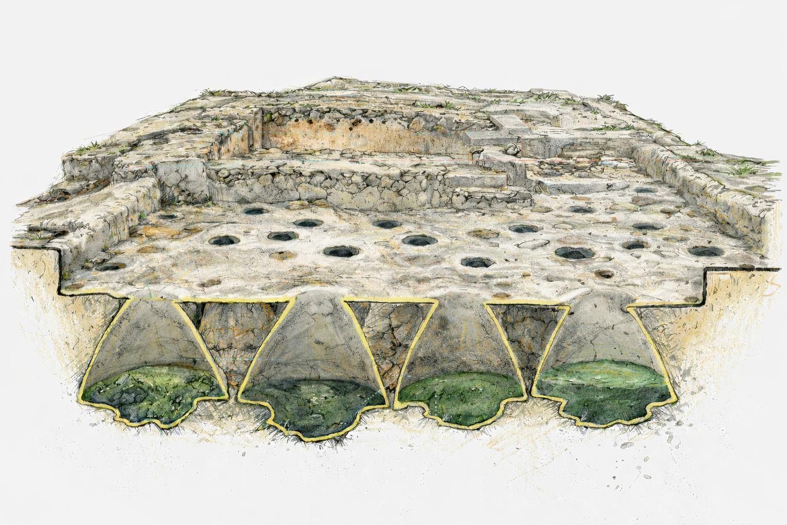
Rock-cut production units described as “distillery” in the publication.[10]
The structures are associated with the Roman and Byzantine periods.[10]
INVENTORY / 2007–2022
MARDİN PROVINCIAL CULTURAL INVENTORY
Çelbira Workshop Area record
The inventory locates the site in Nur Neighbourhood, Artuklu district, approximately 6 km north of central Mardin and about 1 km west of the former Mardin–Diyarbakır road. The workshop extends across the top and the northern and southern slopes of a limestone outcrop and is locally known as ‘Dere’.[9]
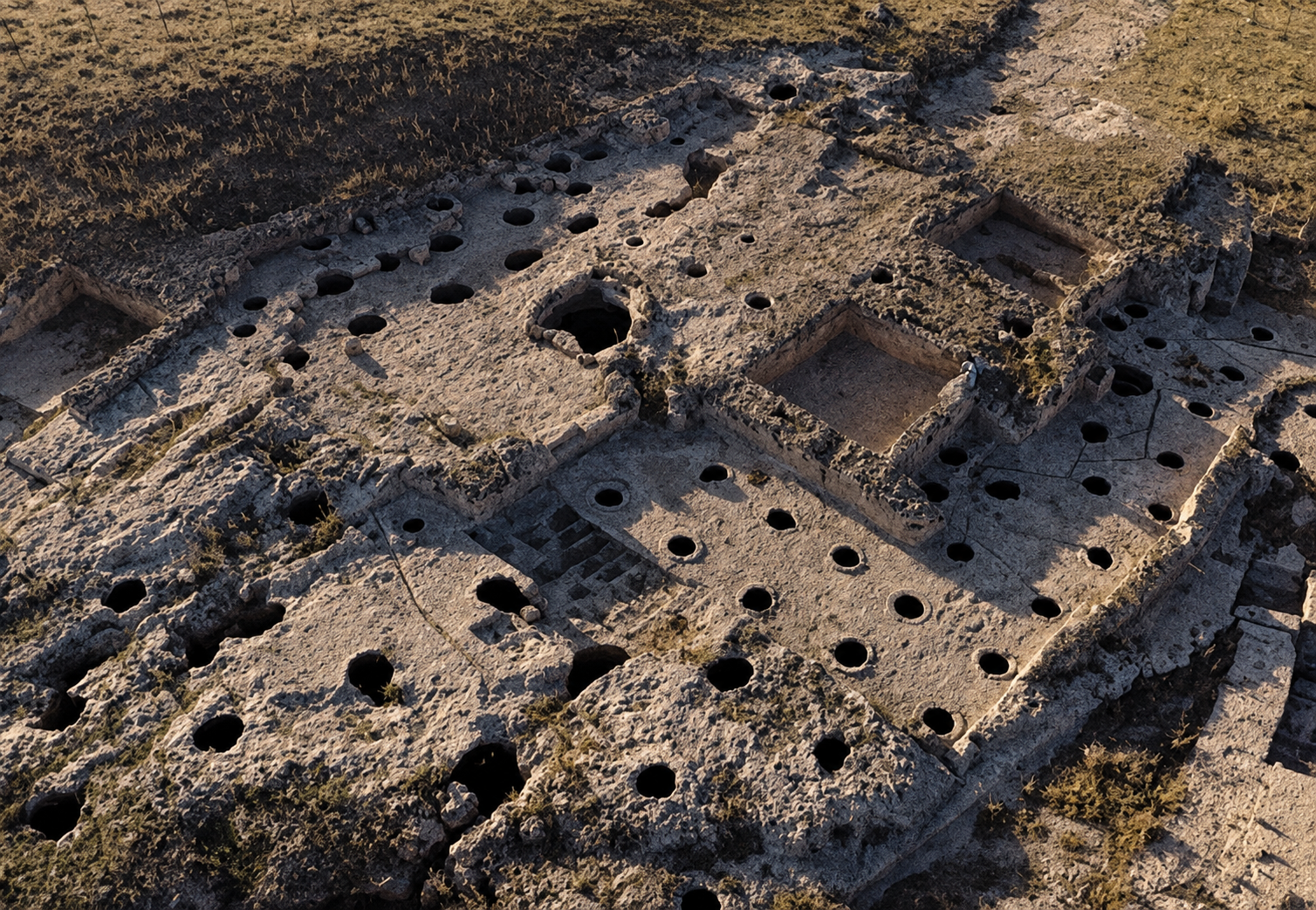
Based on aerial photographs from 2007 and excavation-cleaning work by the Mardin Museum Directorate, the record notes a threshing floor, storage spaces at different stages of completion, approximately 90 chambers and five grape-pressing basins. Coins recovered from the site indicate use beginning no earlier than the Late Roman period.[9]
The figures in the 2007 inventory record and the 2025 study reflect different documentation periods and scopes of work.
INTERACTIVE REPRESENTATIVE PLAN
Cistern atlas
Select a point to inspect its representative record card. This diagram is not a measured survey of the site.
N
↑
↑
documented partial at risk
02 / DOCUMENTATION
DIGITAL CONSERVATION APPROACH
Measuring,
recording and communicating the site.
Field documentation
Recording the wells, surface traces and production units through photography, observation and location data.
3D modelling
Combining drone imagery, photogrammetry and LiDAR data in a measurable digital model.
Augmented reality
Experiencing the documented data on site or remotely in relation to the physical remains.
DIGITAL ARCHIVE
A layer that does not replace the past,
but expands access to it.
A production landscape carved into stone
Çelbira consists of rock-cut cisterns, channels and grape-pressing areas on sloping ground overlooking the Mardin Plain. Together, these features make it possible to read how water and grape must may have been directed through the topography.
03 / PROJECT
TÜBİTAK 2209-A
The digital memory of the Çelbira Ancient Wells
The project aims to document the Çelbira Ancient Wells through augmented-reality technologies and make cultural heritage visible again through the visitor experience.
It brings architecture, archaeology and digital technology together on a shared working ground, seeking to maintain a balance between preserving, interpreting and opening existing data to public access.
REFERENCES
References
[1] Akbaylar Hayreter, I., Gulec Ozer, D. and As Cemrek, H. (2024). Enhancing cultural heritage digitalization and visitor engagement through LIDAR scanning and gamification. Proceedings of the International Conference on Computer-Aided Architectural Design Research in Asia, Singapore, 20–26 April 2024, 2, 283–292. https://doi.org/10.52842/conf.caadria.2024.2.283
[2] Atıcı Tektaş, E. (2024). Kent belleğini Twinmotion ile geleceğe aktarma: Eskişehir Hamamyolu çarşı örneği. Uluslararası Disiplinlerarası ve Kültürlerarası Sanat, 9(18), 51–68. https://dergipark.org.tr/tr/pub/ijiia/issue/86685/1536234
[3] Baratin, L., Zaarour, J. and Tronconi, V. (2023). Protecting, Restoring and Communicating Cultural Heritage in Lebanon: From the “Soab Project” to the Usek Museum. Proceedings of the 11th International Conference of the Arab Society for Computation in Architecture, Art and Design (ASCAAD), University of Petra, Amman, Jordan [Hybrid Conference], 7–9 November 2023, 56–73. https://papers.cumincad.org/cgi-bin/works/paper/ascaad2023_039
[4] Boboc, R. G., Băutu, E., Gîrbacia, F., Popovici, N. and Popovici, D. (2022). Augmented reality in cultural heritage: An overview of the last decade of applications. Applied Sciences, 12(19), 9859. https://doi.org/10.3390/app12199859
[5] Erbaş, E. and Tuncel, D. (2022). Kültür Varlıklarının Sanal Ortamda Yeniden İşlevlendirilmesi: Yerebatan Sarnıcı Örneği. Avrupa Bilim ve Teknoloji Dergisi, (41), 362–372. https://doi.org/10.31590/ejosat.1179021
[6] Fidan, Ş. and Ulvi, A. (2022). Tarsus Aziz Pavlus Kilisesinin yersel lazer tarama teknikleri ile üç boyutlu modelinin oluşturularak sanal gerçekliğe hazırlamanın değerlendirilmesi. Turkey Lidar Journal, 4(2), 60–70. https://doi.org/10.51946/melid.1206504
[7] Gül, L. F., Kilimci, E., Güleç Özer, D., Moralioglu, B. and Çoşkun, E. (2023). Fostering Cultural Heritage Awareness through Game Elements: Route Design for Mixed Reality Experience of the Yedikule Fortress. Proceedings of the 11th International Conference of the Arab Society for Computation in Architecture, Art and Design (ASCAAD), University of Petra, Amman, Jordan [Hybrid Conference], 7–9 November 2023, 652–666. https://papers.cumincad.org/cgi-bin/works/paper/ascaad2023_015
[8] Kalak, D., Güleç Özer, D. and Aydın, S. (2023). Experiencing Cultural Heritage Through Gamification – Mardin orphanage. eCAADe Proceedings, 2, Graz, 20–22 September 2023, 671–680. https://doi.org/10.52842/conf.ecaade.2023.2.671
[9] Kozbe, G. and Güngör, A. (2022). Mardin İli Kültür Envanteri. T.C. Mardin Valiliği, Mardin İl Kültür ve Turizm Müdürlüğü, p. 378.
[10] Kutlu, İ. and Şimşek, D. (2025). Digital Perspectives of Ancient Grape Processing Area with Computational Analysis: Çelbira. SCIRES-IT — Scientific Research and Information Technology, 15(2), 163–180. https://doi.org/10.2423/i22394303v15n2p163
[11] Kültür Bakanlığı. (n.d.). Çelbira üzüm işliği. https://mardin.ktb.gov.tr/TR-312261/celbira-uzumisligi.html
[12] Pieraccini, M., Guidi, G. and Atzeni, C. (2001). 3D digitizing of cultural heritage. Journal of Cultural Heritage, 2(1), 63–70. https://doi.org/10.1016/S1296-2074(01)01108-6
[13] Schnabel, M. A., Aydin, S., Moleta, T. J., Pierini, D. and Dorta, T. (2016). Unmediated cultural heritage via Hyve3D: Collecting individual and collective narratives with 3D sketching. Proceedings of the International Conference on Computer-Aided Architectural Design Research in Asia, Melbourne, 30 March–2 April 2016, 683–692. https://doi.org/10.52842/conf.caadria.2016.683